Friday, May 27, 2016

Golden Glades Interchange Makeover 3

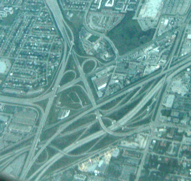
Okay, today I'll show you what the State of Florida is planning to do to make over this bad interchange that's utterly constipated with over 400,000 cars (actually all manner of motor vehicles) a day. Again, I'll first show you what the existing bad intersection looks like:


It's a mess, innit? If you can't figure out how it works from the air or a map, it'll be more difficult to make sense of it while on the ground! There are anecdotes of people getting hopelessly lost in this motorway junction of two freeways, a tollway and six/seven other roads. One of these days there'll be legends of the lost Floridian, wandering through the intersection, getting lost, finding his way out on the wrong road, turniong around and going back in ad infinitum.

Well anyway back in 2014 the State Transportation Department did a study and came up with some solutions. Basically they figured a way to get State Route 826 Palmetto Exway EB to I-95 NB, improve the flow of the Turnpike SB to the Golden Glades park 'n' ride and onto I-95 into Miami, and a lot of minor improvements (some "improvements" I wouldn't call them that) for the near term. This is their "Interim" plan for the interchange. Then theyre going to bring in new High Occupancy/Toll Lanes from the Palmetto Expwy to the I-95 Express Lanes to and from Broward County. and an on-ramp from the Turnpike SB into I-95 Express Lane into Miami. This is their "Ultimate" intent for the motorway junction.

So here without further ado is the State's design for the "Interim" plan, or what I call Stage One:

Revised the layout to more accurately reflect the State of Florida's Interim concept plan.
Also so that the State's Ultimate concept plan will fit with even the slightest bit of accuracy! 
And here I show a simplified bird's eye view: The major widenings, the new roads and viaduct, and one of the reworked traffic lights are highlighted in Spanish Orange. The rest are just shown as-is for your ease of viewing.

Bird's-eye view of the Golden Glades interchange with major "Interim" changes planned by the State shown.

Showing ALL the roads that are going to be rebuilt by 2020 is just going to be too damn much!  And would fill this bird's-eye photo with clutter.

Note the major do-overs:

1.  New connector ramp from State Route 826 EB to I-95 NB (on viaduct).
2.  Expansion of the Turnpike Connector SB (which really should be the mainline due to the amount of traffic it carries) to I-95 into Miami. This is going to be at its widest five travel lanes and two breakdown lanes.
3.  Widening and increasing the turning radius of the ramp from S.R. 826 EB to I-95 NB.
4.  Reworking the traffic lighted intersection of NW 7th Ave Ext and the Turnpike on-ramp so there are two left-turn "doghouse" lanes from S.R. 826 EB to the Turnpike NB.

Next I'll show you the State's "Ultimate" plan and tell you what's missing (a few vital freeway-to-freeway/tollway connections and vice-versa without traffic lights) and see how I can fit my ideas for this rat's nest with their plans.

31 May 2016 UPDATE: Revised my "stage one" or the State's "Interim" layout image, second one from the top, for accuracy purposes and to fit their "Ultimate" layout in. 

2 JUNE 2016 UPDATE: Revised marking for the I-95 Express lanes to a smaller marker in a more obvious location.


Friday, May 20, 2016

Golden Glades Interchange Makeover 2

Updated 22 May 2016

Well I have an idea... make a Northside Connector direct from the Palmetto Expressway to I-95 North and call it I-495. Also make improvements to the end of the Turnpike and make it FL I-91. Basically it involves the construction of a new limited-access highway with three-quarters of a stack interchange at the intersection of the Palmetto and the Turnpike.


Bird's eye view. Looking Northeast. Turnpike runs from center-left to lower right, Palmetto is at lower left. I-95 runs up the right side, bottom to top. The Northside Connector with ramps in red runs from the Palmetto at lower left to I-95 at the top. Surface roads called NW 167 St 7th Ave Ext and US 441 North in yellow.


Plane eye's view. Turnpike & Turnpike Connector (FL I-91 TPK) and Palmetto/Northside Connector (I-495) both in blue. I-95 Express Toll Lanes viaduct in purple. Ramps in Red. Surface roads in yellow.

Here you can clearly see that the (new) FL I-91 TPK mainline here follows the bulk of the traffic to and from I-95 out of Miami. The I-495 Northside Connector follows the existing NW 167 St 7th Ave Extension on a viaduct beginning just east of the existing Turnpike - NW 167 St North Miami Beach connector. The existing surface road below is reconfigured as shown in yellow. The ramps are shown in red.
The are four high-level ramps; they carry traffic:
(1) From (I-95) FL I-91 TPK NB to I-495 Palmetto X-way WB
(2) From I-495 Palmetto Xway EB to FL I-91 TPK NB
(3) From FL I-91 TPK SB to I-495 Northside Connector EB (I-95 NB), and
(4) From (I-95 SB) I-495 Northside Connector WB to I-91 TPK NB.
There are also two high-capacity ground-level ramps:
(1) FL I-91 TPK SB to I-495 Palmetto X-way WB
(2) I-495 Palmetto X-way EB to FL I-91 TPK (I-95) SB
Plus there is a two-branched ramp to the Golden Glades Park-and-Ride from the FL I-91 TPK SB and the I-495 Palmetto X-way EB.

The existing interchange of the existing Rte. 826 overpass connecting the Turnpike to NW 167 ST Miami Beach is tweaked:

(1) There is an I-495 eastbound surface road turnoff for NW 167 St 7th Ave Ext and NW 7th Ave North, because you know how traffic backs up at a light.
(2) The existing ramp to NW 167 St Miami Beach is rebuilt so the surface road turnoff can pass underneath.
(3) The existing off-ramp from the Rte. 826 overpass is tweaked to accommodate a merge from the reconfigured NW 167 St 7th Ave Ext.
(4) The existing on-ramp from NW 167 St 7th Ave Ext to the FL I-91 TPK NB is tweaked to accommodate the new high-level ramp no. (4) above.
(5) The existing Rte. 826 overpass feed-in to the turnpike is tweaked to accommodate the new FL I-91 TPK mainline and high-level ramp no. (2) above.
(6) The existing ramp from the FL I-91 TPK SB to Rte. 826 EB is extended or relocated as necessary.
Other:
(1) The existing ramp from Rte. 9 / US 441 NB to FL I-91 TPK NB is tweaked and extended to provide access to the I-495 Palmetto X-way WB via the new high level ramp (1) thereto.
(2) The existing US 441 ramps from the Golden Glades Interchange mess at I-95 to NW 2nd Ave are rebuilt / regraded as necessary to accommodate the new round-a-bout.
(3) New slip ramps are included to connect the reconfigured NW 167 ST Ext and NW 7th Ave to the I-495 Northside Connector to and from I-95 (westbound off-ramp west of the round-about, eastbound on-ramp from and east of the round-a-bout).
(4) The existing quarter-cloverleaf from FL I-91 TPK NB to I-495 Palmetto X-way and the existing ramp from I-95 SB to the Rte. 826 overpass WB are done away with.
But the rest of the Golden Glades Interchange that sits on the south side of the railroad tracks, I have no idea how to disentangle it; it's such a mess of spaghetti!

22 May 2016 Update: A tweak on the ramps from the I-91 TPK SB to I-95 SB, I-495 SB, I-495 (95) NB, Rte. 826 EB, etc., would be to have the ramp to I-95 SB/Rte 495 WB/Golden Glades Park-and-Ride split off of the ramp to I-495 EB/Northside Connector instead from the ramp to Rte. 826 EB/North Miami Beach.

Of course, the state has its own ideas, with a design based on what they predict the Average Daily Traffic (ADT) will be in 2040.  Now thanks to climate change and the sea-level rise at Miami and its effects on the porous limerock-encased Biscayne Aquifer, the ADT at this interchange might be... exactly... zero!

So I don't expect my makeover to be built, either.

Thursday, May 19, 2016

Golden Glades Interchange Makeover

If you look at a detailed map of Miami's Golden Glades interchange, it is a MESS! Some movements can't be done without going to a far end of the interchange and back through a loop and several weaves. Another movement involves waiting in a doghouse lane waiting for a traffic light to change.

Source and Copyright: farm5.staticflickr.com
And yet at the same time it looks so convoluted, where ten arteries - four of them expressways - come together at one point that it appears impossible to improve it without acquiring a LOT of property! Any ideas? Put it in the comment box and provide a link to a more detailed expression of your idea.

Thanks!

Thursday, May 5, 2016

New Route Marker for Arkansas

This is based on Arkansas being the home to the Diamond Crater State Park; and the reverse of their State Commemorative Quarter bearing a diamond right underneath its date of establishment.


Size of the sign blade will be about 26¼ in. by 24 in. Height of the numerals 10"

Friday, April 22, 2016

New Arizona Sign

This one is based on their license plate. (The one I created before was based on their flag.)


It's a simple design, with the state name bannered at the top in Candara typeface about 5" height and the route number in big (12") numerals in the middle in the US Series D Highway Gothic typeface. The state nickname is at the lower right in the same typeface as on the license plate, scaled up with the scenery on the bottom.

Friday, April 8, 2016

Miami-Dade Transit

***Revised and Expanded April 9, 2016****

This is quite a detour from the International Highway Makeover but there is more than one way of making over highways. For instance, you can alleviate the choked traffic on them by building... SUBWAYS! That's right, subways. Heavy rail rapid transit, whether underground in tunnels, depressed tracks in trenches, right on the ground surface, elevated on levees, or overhead on skyways, will alleviate traffic on surface highways once they are attractive enough and there are enough of them.

Originally the system was envisioned as two branches to the northwest, one branch to the west and one line to the south. Other extensions were also put on the table and thought about. Here's what Wikipedia has to say about all this:


One variation of the Orange Line extensions was for a continuation passed the current airport station instead of the 1984 ghost platform at Government Center.

From the beginning, the Metrorail was designed and envisioned to have more lines than the current two line system; however, the federally subsidized cost of the original line ended up over budget at $1.02 billion,[9] after which ridership was much lower than expected. The proposed lines included:[18]


You can obtain a more in-depth discussion of the above and other extensions at this link here (30 Mb PDF).


One variation of the Orange Line extensions was for a continuation
past the current airport station instead of the 1984 ghost platform at Government Center.
Source Credit: FrickFrack at English Wikipedia

Back in 2010 I found a map drawn up by someone from Miami and they had an idea for many extensions:


Credit: NOT KNOWN
Whoever came up with this give me a call-out!

I do not know what has happened to this jpeg image since Miami-Dade Transit officials pulled the east-west Orange Line extension past the Airport and the other Orange Line extension north past NW 79th Street off the table and opted only for the Earlington Heights-Miami Central Station Connector.

 
And here is my take on the extensions above map. Watch out - it's huge (10.2 Mb)!

My Modest Proposal.
 
 
I think the first priority should be to build the Royal Palm Line, or Green Line, down to Cutler Ridge, extend the King Orange Line from Earlington Heights out to the west end of Arthur Godfrey Road in Miami Beach, and begin the Gold Coast Line from Downtown Miami north to at least the Design District, or better yet, Biscayne Plaza. Second on the agenda should be the construction of the Port Deco (Blue) and Central (Red) Lines from the Airport via the Orange Bowl and NW 7th St to Government Center and at least Port of Miami East, the extension of the Gold Coast Line further north, and the extension of the Tri-Rail down to Tamiami Airport. Third would be the completion of the Port Deco Line to Beach 5th St, the start of construction on the King Orange / Central Lines to FIU Tamiami and the completion of the northern Gold Coast Line to and perhaps into Broward County. Fourth would be the extension of the Gold Coast Line down to Florida City (of course this could be done earlier since Miami-Dade County owns the right-of-way so construction will be cheap) and the construction of the Citrus Line from the Airport to Douglas Road. Last would be the extension of the Citrus Line north to Calder, because, well, look where it's going!

The best way to do this I think is to extend Miami-Dade's half-penny tax for rapid transit over Broward and Palm Beach Counties and give the money AND the Metrorail / Metromover system over to Tri-Rail since at least they haven't been notoriously conspicuous in political corruption AND they can build Metrorails in those two counties, too, with the money. Which they should.

So what do you think of it?  All other things being equal, do you Miami-Dade Countians think it's a good rail rapid transit plan?

Yes, I know Miami is doomed because of AGW. In fact, it's supposed to become uninhabitable long before the seawaters flood the county's interior and coastal zones due to their infiltration of the groundwater in the Biscayne Aquifer, which South Floridians use for their drinking water. One or two drinking water wells have already been put out of commission due to this.

Monday, April 4, 2016

Suggestion for the New Jersey Turnpike Authority!

HEY YOU GU-U-U-U-YS!

The signs for the Masssachusetts and Delaware tolls are simple, concise and informative enough... in other words, looking good! But the south end of the Jersey Turnpike is a completely different story.

Source: pixelmap.com.
I mean, LOOK at all this crap! Just look at it!

You have a small sign over the high speed lane bearing the message, "E-ZPass EXPRESS LANES" with an electronic screen, supposedly indicating when the lanes are closed. (And why do you need to close the E-ZPass lanes anyway? Just have a spare lane like normal turnpikes!)

The other sign over the right travel and breakdown lanes is just overcrowded with a lot of messages, which makes it very difficult to read at 65, 70 miles an hour. Six lines of text on the left, five on the right. And some of those messages are unnecessary! (Such as if it's a toll tags only lane, you don't need the additional "NO CASH" message. And the "REDUCE SPEED" is also unnecessary; the drivers know there's a toll plaza coming up, they have to reduce speed! Except in the toll tags only lanes, of course -- those guys can speed right through. And even with the "NO CASH" message, it's hard to tell if cash is not accepted in the right travel lane and very impossible to tell is cash is not accepted in the high speed lane.

And that's without the distraction of the flashing yellow lights.  I wonder if drivers have rear-ended others while trying to decipher this sign, HAHAHA.

Maybe the NJTA should consider extending the auxiliary turnoff lane back to this sign if rear-end collisions are a problem.

Well I've come up with a better one, based on my "E-ZPass TAGS ONLY" sign in the previous post. First, I merged two signs into one for two lanes restricted to toll tags only.


Voila! Simple enough, Jerseyites?  It's bottom message, "TAGS ONLY" in regulatory black-and-white for each lane clearly indicate that cash is not allowed.  This can be installed on the sign bridge that's off in the distance.

Now for the replacement sign on the immediately near sign bridge:


Now this sign, suspended over both travel lanes and breakdown lane gets the message across for both toll tag holders and cash toll payers much more quickly than all that illegibly small and crowded stuff the NJTA put on their sign.  Everything is simple and concise. The cash toll payers are instructed to bear right, while the toll tag holders can breeze on through. (And the word "THROUGH" is spelled correctly, too.)

But if you think you need the "NO CASH" message for each toll tag lane, just get rid of "ALL LANES THROUGH" and scoot up the "E-ZPass" and "CASH" messages to make room for "NO CASH" in the regulatory black-and-white field directly under each "E-ZPass."

Now back to the far sign bridge, here's my design for the cash toll lanes guide sign on the right:


This is simple enough, too. Only three lines of text and two turnoff arrows, one over each lane.

Now for the big enchilada... how it will look like in real life.


Ta-da!